
The world’s coasts have long been foci of human occupation. They provide easy access to a variety of food resources and the potential for efficient movement, communication, and transport over waterways. Just as coasts bear large populations and are economically important today, archaeological evidence also demonstrates that they were important places for people long into the past on all habitable continents. The archaeology of coasts provides key windows into some of the most fascinating topics of human history on the planet: early migrations and colonizations of continents, mobility and interconnectedness, cosmologies and spiritualities, and economies and subsistence pursuits that were viable alternatives to the often over-emphasized human achievement of agriculture.
I am part of several research projects affiliated with several universities and collaborating with multiple First Nations up and down the coast of British Columbia, though the majority of my work is focused around the north coast of the province: the area between Prince Rupert and Douglas Channel. These projects focus on a variety of different aspects of coastal archaeology. For details on some of my projects and some of the more interesting results, scroll down.
Sea Level Change
Relative Sea Level Change
The vertical position of the ocean relative to the land is in a constant state of flux, on daily and millennial scales. I study relative sea level (RSL) change through time in order to reconstruct ancient coastal landscapes. On the Northwest Coast of North America, which was heavily glaciated, RSL change since the end of the Ice Age is primarily a result of changes in the amount of water in the oceans (eustatic sea level - largely dependent on the amount of water locked up in the Earth’s ice sheets) and the vertical displacement of the earth’s crust related to loading (downward motion) or unloading (upward motion) of glacial ice (or - to a lesser degree - sediment or water). This latter process is referred to as isostatic depression and isostatic rebound. Because both eustatic sea level and isostatic processes are largely influenced by glaciers, the scale, pace, and timing of relative sea level change on the Northwest Coast is spatially variable, dependent on the size and position of ice sheets and the timing and rates of deglaciation. At a single moment in time, an offshore location that is deglaciated may be isostatically uplifted (and the position of the water relative to the land - RSL - will be lower) while a location on the mainland that was just deglaciated and is adjacent to the ice sheet will be isostatically depressed (and RSL will be higher). Other factors contributing to RSL change include the tectonic motion of Earth’s plates relative to each other, which can cause either slow uplift or subsidence or very rapid vertical motion when there is an earthquake; and the steric expansion or contraction of water as a result of changing global temperatures.
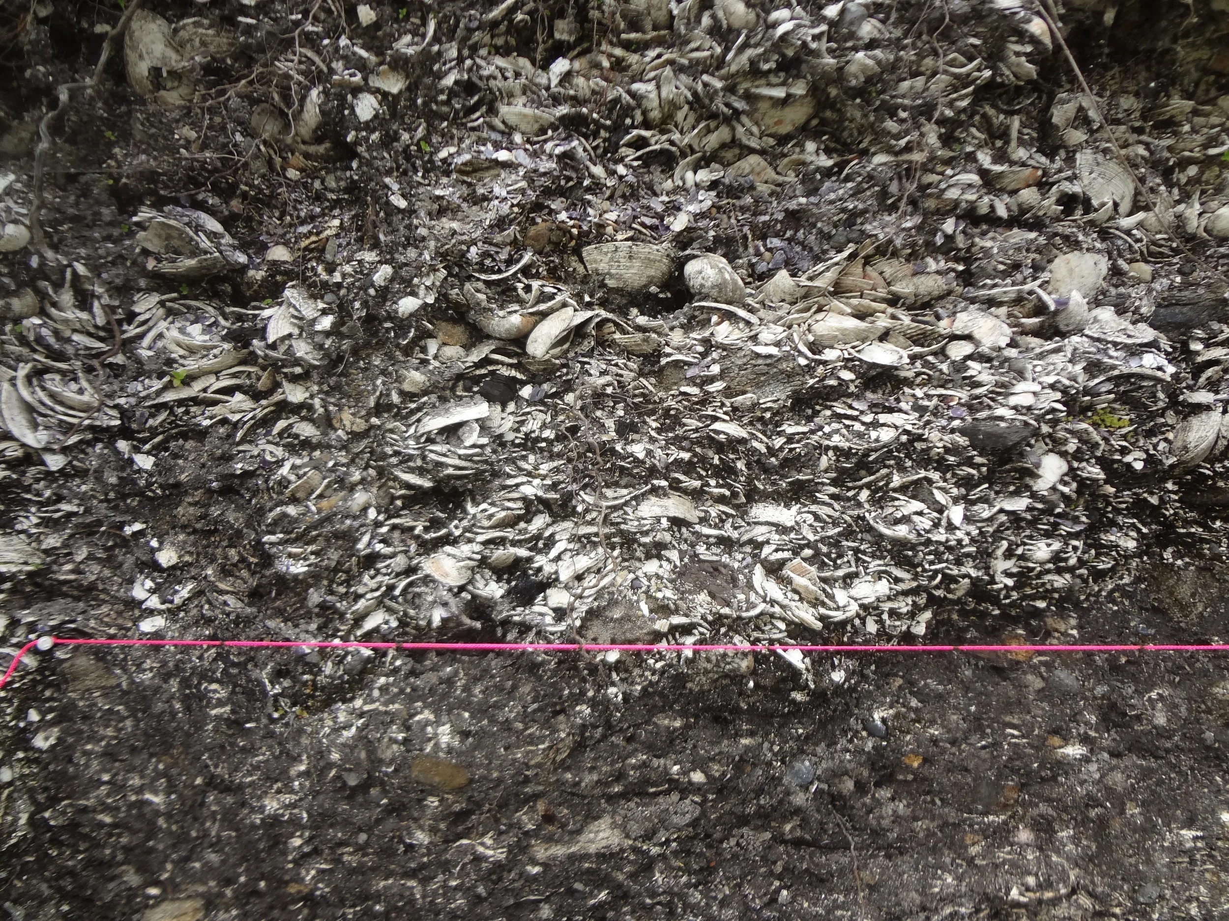
Marine clam shells exposed in a bank of the Quaal River, 13 km upriver from the ocean coast today. Photo by B. Letham.
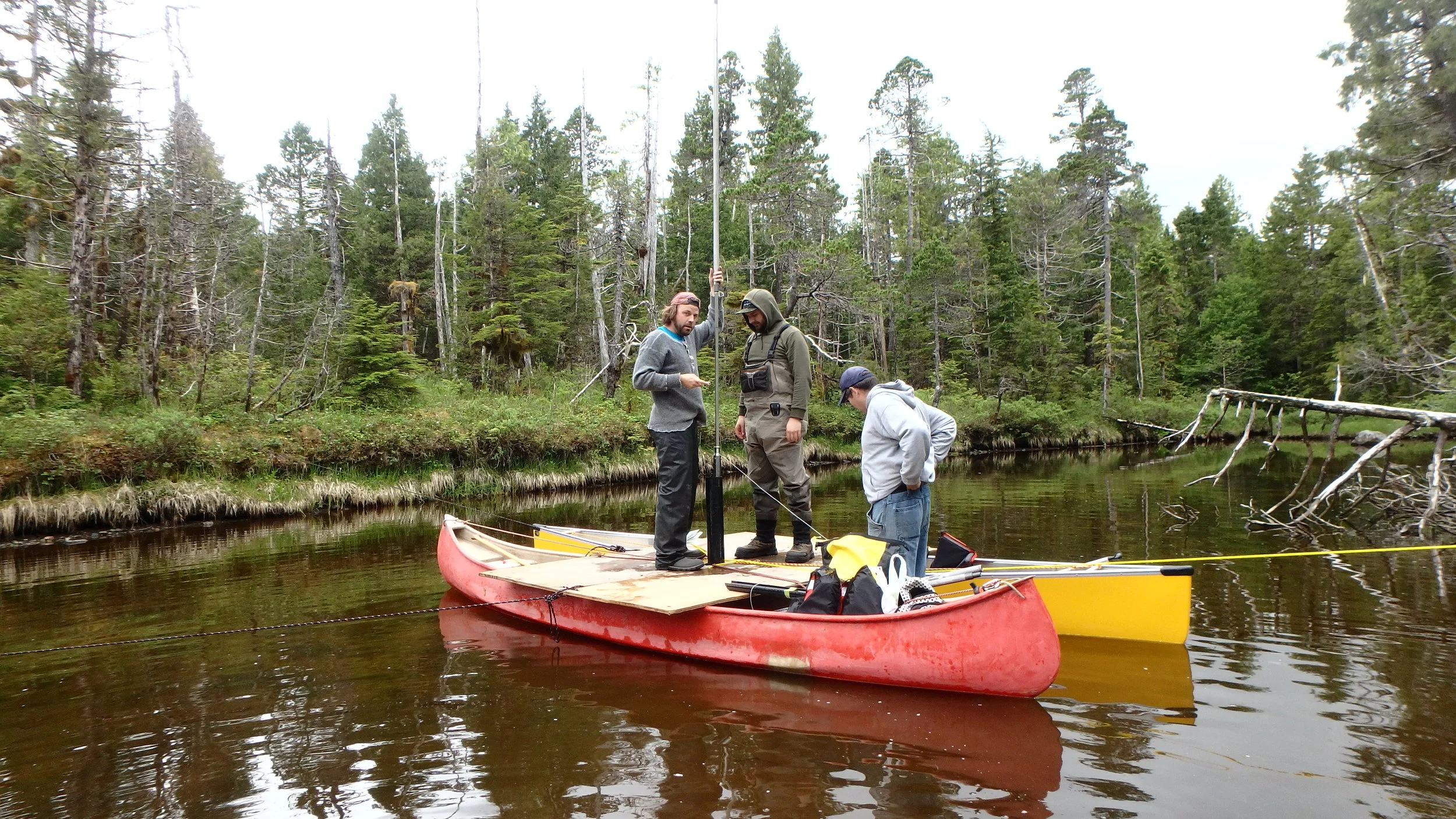
To reconstruct RSL histories I collect data that either directly indicates or constrains the elevation of sea level at various points of time in the past. For example, marine shells in beach sediments above the current sea level indicate that RSL was higher in the past; forest soils or tree stumps in the intertidal or subtidal zone can indicate lower RSL. One of the primary methods that I gather data on RSL position is through coring lakes, bogs, ponds, and lagoons at various elevations and examining microfossils in the sediment sequences accumulated at the bottoms for indications of changing depositional environments. Diatoms are microscopic single-celled algae with silica cell walls that are very sensitive to changes in salinity; through identifying transitions from freshwater to marine diatom species assemblages in the cores and radiocarbon dating organic material from these transitions we can discover when sea level was above and below the whatever elevation the body of water is at. Additional data indicating the position of past sea level can include the elevations of dated archaeological deposits that we assume are from sites close to but above the high tide line, and geomorphic features such as beach ridges or notches cut into bedrock by waves that are above the current sea level.
A lake core from near Prince Rupert, British Columbia. Today this freshwater lake is 35 m above sea level. Radiocarbon dates from above and below a transition from marine to freshwater conditions evident in the diatom assemblage indicate that prior to 13,500 years ago this location was a marine basin, and sea level was at least 35 m higher than at present. After 13,500 years ago, sea level dropped below 35 m asl.
With enough data constraining RSL position through time we can generate RSL curves, which provide an estimate of sea level position through the given time range. These are useful for modelling ancient shoreline positions and for designing archaeological surveys that seek to identify sites from times when RSL was different from that of today. This is especially critical for searching for the earliest evidence of human occupation of the coast after deglaciation, as for the most part, shoreline positions were most different from that of today during and immediately following the last Ice Age.
The inferred relative sea level curve for the Prince Rupert Harbour area (elevation vs. time), originally published in Letham et al. 2016.
For example, between 2013 and 2016 I gathered data to refine the RSL history of the Prince Rupert area and found that 15,000 years ago, RSL was at least 50 m higher there than today. Therefore, if people had been in the area immediately after it was deglaciated, archaeologists would have to look at locations above 50 m asl; everywhere below that would have been under water at the time. The isostatic rebound of the earth’s crust around Prince Rupert after the weight of the ice sheets had been removed caused RSL to drop very rapidly from it’s current position to an elevation at least 6 m below sea level today by about 13,000 years ago. After this initial dramatic isostatic response, eustatic sea level rise caused by the melting continental ice sheets caused RSL to rise up again 6-8 m above it’s current position around 10,000 years ago, and a likely combination of tectonic motion and slower isostatic adjustment caused it to slowly drop to today’s position. I used this RSL reconstruction to identity 6000-9000 year old archaeological sites on raised paleoshorelines stranded back from today’s shorelines - the oldest currently recorded archaeological sites around Prince Rupert. Future researchers in the area can now use this RSL curve to look for more early Holocene sites, or to attempt to push the record of identified sites around Prince Rupert back to the Late Pleistocene.
More recently, I have helped to reconstruct RSL histories for the central and southern Douglas Channel region as part of the ‘Old Town Project’, a joint project between the Gitga’at First Nation and Simon Fraser University. This is part of a larger project of documenting variation in RSL change across the northern coast of British Columbia in order to be able to model landscape transformations from the deglaciation of the region through the Holocene. To this end, beginning in the summer of 2019 (and currently continuing) I began collecting data for RSL reconstruction of some of the furthest offshore islands on the northern coast of British Columbia (excluding Haida Gwaii).
Relative Sea Level Curves for Vancouver Island, including the four RSL curves that we have reconstructed for the northern area of the Island (Port McNeill, Port Hardy, Eastern Quatsino Sound, and Outer Quatsino Sound; see Letham et al. 2024 for original publication).
I have also recently completed a major study of sea level change on northern Vancouver Island with a large team of researchers affiliated with the Hakai Institute. We reconstructed RSL histories for four different regions of northern Vancouver Island (Port McNeill, Port Hardy, Central Quatsino Sound and Western Quatsino Sound), and documented significant variation from one to the other - largely related to complex and different histories of glaciation and deglaciation. Notably, the far outer coast of northern Vancouver Island was ice-free very early on following the Last Glacial Maximum - by at least 18,200 BP. This project is working to reconstruct the landscapes and paleoecology of these early ice-free areas to explore the potential for locating very early evidence of human occupation on the Northwest Coast. Future work will expand our RSL reconstructions even further north, to the very tip of Vancouver Island, as well as south along the west coast of the Island towards Kyuquot and Nootka Sound.
For more information on post-glacial relative sea level change in general, and on the Pacific coast of North America, see the following sources:
Pirazzoli, P.A. 1996. Sea-level changes: the last 20 000 years. Chichester, UK: Wiley.
Shennan, I., A.J. Long and B.P. Horton, eds. 2015. Handbook of Sea-Level Research. Wiley Online Publishing.
Clague, J.J., J.R. Harper, R.J. Hebda, and D.E. Howes. 1982. Late Quaternary Sea Levels and Crustal Movements, Coastal British Columbia. Canadian Journal of Earth Science 19:597-618.
Engelhart, S.E., M. Vacchi, B.P. Horton, A.R. Nelson, and R.E. Kopp. 2015. A Sea-Level Database for the Pacific Coast of Central North America. Quaternary Science Reviews 113:78-92.
Shugar, D.H., I.J. Walker, O.B. Lian, J.B.R. Eamer, C. Neudorf, D. McLaren, and D.W. Fedje. 2014. Post-glacial sea-level change along the Pacific coast of North America. Quaternary Science Reviews 97(1):170-192.
Coastal Built Environments
Culturally Modified Coastlines
The Northwest Coast of North America is often viewed as a wild and rugged landscape; today very little of it is accessible by other means than boat, let alone inhabited. The archaeological record, however, demonstrates that prior to European colonization the region was densely occupied by the ancestors of First Nations living in large groups up and down the entire stretch of coast. Even more striking is the degree to which these peoples modified and managed the world around them, often transforming the physical landscape and the biosphere in ways that had beneficial implications for generations of subsequent occupants. One of my research interests is exploring the ways in which the Northwest Coast was shaped by humans, and the implications of anthropogenic transformations to the coastal environment.
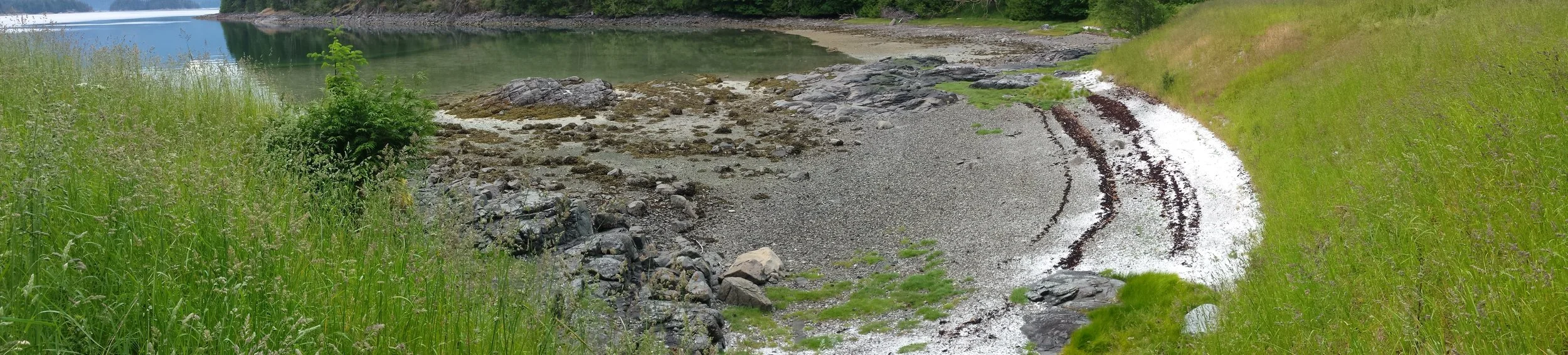
Rows of canoe runs formed by clearing lanes within boulders in front of an ancient village on Garden Island, Prince Rupert Harbour. Photo by B. Letham.
The ancient inhabitants modified everything from the land on which they lived to the beaches on which they landed their canoes and gathered resources. For example, they constructed ‘clam gardens’ by clearing beaches and rolling large boulders to the low tide line in order to build up a terrace that effectively extended the beach surface with ideal sediment conditions for bivalve growth at whatever elevation was ideal for an intended clam species. They also constructed stone and wooden fish traps in the intertidal zone and at river mouths to corral and capture certain fish species, and cleared boulders from beaches to make cleared paths for canoes (‘canoe runs’) to access important landfalls. In the riverine wetlands near the mouth of the Fraser River, people paved marshy areas with cobbles to facilitate the optimal growth and harvesting of wapato, a tuber important in the diets of Coast Salish peoples. Above the high tide line, forests were intentionally cleared and burned to create areas to live or to cultivate and encourage growth of specific vegetation. People constructed earthworks and dug trench embankments to increase defense, and built earth mounds and stone cairns as graves for the dead. Often, entire landforms were altered to create habitats that promoted increased resource diversity and gathered key resources closer to villages. The villages in which people lived consisted of monumental wooden houses that stood as prominent landmarks on the water’s edge, and which served as important markers of lineage and ownership of territories.
A culturally modified coastline on Quadra Island, in the Discovery Islands on the south coast of BC: at the far edge of the intertidal zone (flooded by water in the photo) is rock wall for a clam garden, in the center of the photo is a canoe run through a boulder and bedrock patch, and above the beach is a flat landform consisting almost entirely of accumulated shell, on which a village once stood. Photo by B. Letham.
Four-meter-deep shell deposit at Garden Island in Prince Rupert Harbour. The above-tide portion of the island is made almost entirely of human-deposited shell and other cultural debris. Photo by B. Letham.
The large ancient village sites on the north coast around Prince Rupert and the nearby islands are associated with spectacular amount of marine shell that has been deposited by people through time. Most often, plank houses were built in rows directly on top of these shell accumulations. In some cases, these shell deposits are over 6 meters in depth and thousands of square meters in area - making them effectively quite substantial modifications to the shorelines. In my research I explore the practical effects of these massive accumulations of cultural sediment for the people who lived on top of them. Using percussion coring and radiocarbon dating to assess the shape of the natural ground surface beneath the archaeological site, the difference between that and the surface created by shell deposition, and the pacing of this deposition, I have found that in some cases at some parts of these villages large amounts of shell have been deposited very rapidly in a way that either levels a sloped land surface or extends a flattened surface. It seems that at certain points in time during a village’s occupation, people coordinated the deposition of shell in order to shape the land towards a specific end, either to generate a raised, well drained terrace that was more amenable to living upon, to buffer against foreshore erosion by waves, or to construct ridges of shell behind villages that were used as cemeteries or which may have served as defensive bulwarks at the back sides of villages.
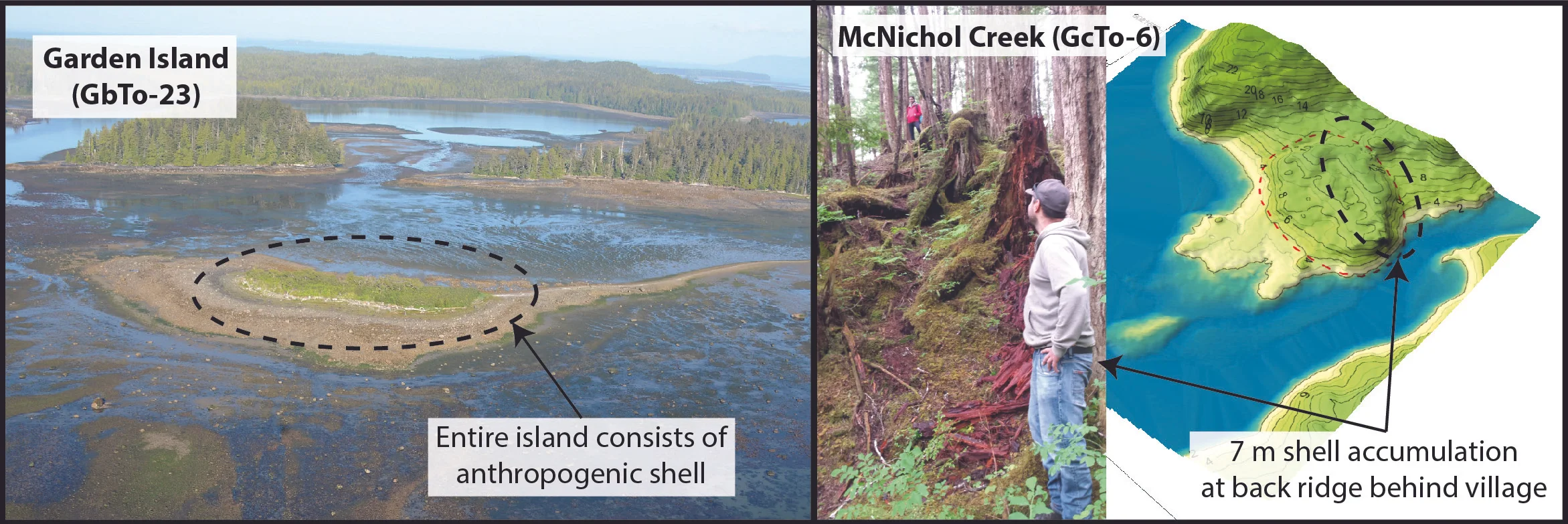
Examples of shell deposition that significantly transform landforms at Prince Rupert Harbour villages: Garden Island is an island almost entirely constructed of anthropogenic shell. Photo courtesy of Coastal and Ocean Resources and the Prince Rupert Port Authority (http://www.rupertport.com/port-authority/sustainability/shoreline-habitat). At the McNichol Creek village site (GcTo-6), a ridge of shell rises 7 m up from the natural landform behind the village. In the inset photo, the person in the red jacket stands on the crest of the ridge while the person in the foreground is standing at the base of the ridge behind the site on the natural ground surface. Photo by B. Letham.
In addition to the functional benefits of these ancient modifications (increasing/managing resource production, making land more amenable to occupation), some of my research suggests that these had deeper cultural implications, and played a key role in structuring people’s attachments to place and political negotiations over space. One major interest of mine is exploring the ways in which people’s relationships to places vis-à-vis management and modification may play a role in the development of systems of land and resource tenure and proprietorship, which are hallmarks of indigenous culture and reflected in indigenous law, but which are also contentious issues in the present political landscape, where BC First Nations are often denied rights to land and resources by colonial governments.
House mounds at Galahahaaytk/Man-Made Island. From left to right, Ginevra Toniello, Dana Lepofsky, and Spencer Greening stand on and in between two mounds on which plank houses once stood. The low area in the middle floods during high high tides, while the areas raised for houses remain above water and dry. Photo by B. Letham.
My ongoing research focuses on ways to identify and study anthropogenic landforms using geoarchaeological methods. One method that I am exploring is the application of micromorphology - the study of microscopic sediment characteristics and microstratigraphy observed on thin section slides - to Northwest Coast sites to understand more about the specific depositional practices behind (and literally beneath) large villages. My research on the massive shell deposits around Prince Rupert Harbour continues, and I am also working with Dr. Dana Lepofsky (SFU), Spencer Greening (Gitga’at Nation/SFU) and members of the Gitga’at Nation to explore the village of Galahahaaytk in the Quaal River estuary, which is locally colloquially known as ‘Mad-Made Island’. Galahahaaytk consists of a single row of 10 rectangular mounds on which houses once stood on a narrow island near the mouth of the river. During the highest tides of the year, the entire island floods except for the tops of the mounds; the houses that once stood on these mounds would have stayed dry. Our explorations of the site seek to unravel how much of the island was ‘man-made’, and specifically how it was made. The site was excavated by the famous anthropologist/archaeologist Philip Drucker in 1938; we have conducted minimally-invasive explorations of the site by re-locating Drucker’s trenches and clearing them of backfill to expose the stratigraphy of the mounds that he exposed 80 years ago, and conducting small test excavations on the edge of another mound. Through a combination of macro- and micromorphological analysis of the sediments and stratigraphy, and dating the occupation and formation of the island we are working towards telling the history of this culturally significant place.